Under North Dakota law, the Board of University and School Lands (Board) is vested with the authority to manage state-owned minerals including the oil, gas, and related hydrocarbons within the beds of the State’s navigable waters.
The Sixty-Fifth Legislative Assembly's adoption of Senate Bill 2134 (SB 2134), codified as N.D.C.C. ch. 61-33.1, sought to establish state ownership of minerals below the ordinary high water mark of the historical Missouri riverbed channel (Historical OHWM) inundated by Pick-Sloan Missouri basin project dams. The bill directed the North Dakota Department of Mineral Resources (DMR) to procure a qualified engineering and surveying firm to conduct a review of the US Army Corp of Engineers (USACE) survey segments limited only to the corps survey segments from the northern boundary of the Fort Berthold Indian reservation to the southern border of Sections 33 and 34, Township 153 North, Range 102 West.
The Historical OHWM review as prepared by Wenck Associates, Inc. (Review) was presented to the North Dakota Industrial Commission (NDIC) on April 17, 2018. Thereafter, the NDIC issued its September 27, 2018 Order of the Commission, Order No. 29129, approving the Review. Information concerning the Review can be found on DMR’s website.
Senate Bill 2211 of the Sixty-Sixth Legislative Assembly amended N.D.C.C. ch. 61-33.1 relating to the ownership of mineral rights of land subject to inundation by Pick-Sloan Missouri basin project dams. Under N.D.C.C. § 61-33.1-03(8), the Board contracted with Kadrmas, Lee & Jackson, Inc. (KLJ) “to analyze the final review findings and determine the acreage on a quarter-quarter basis or government lot basis above and below the [Historical OHWM] as delineated by the final review findings of the industrial commission.”
On June 25, 2020, the Board adopted the acreage adjustment survey on a quarter-quarter basis or government lot basis above and below the ordinary high water mark as delineated by the final review findings of the NDIC except T152N R93W Section 10 Lot 6, Section 11 Lot 2 and T153N, R102W Sections 19, 20, 21, 22, 23, 25, 26, 27, 28, 29, 30, 33, 34, and 36.
On November 24, 2020, the Board adopted the acreage adjustment survey on a quarter-quarter basis or government lot basis above and below the ordinary high water mark as delineated by the final review findings of the NDIC for T152N R93W Section 10 Lot 6 and Section 11 Lot 2.
On November 29, 2021, the Board adopted the acreage adjustment survey on a quarter-quarter basis or government lot basis above and below the ordinary high water mark as delineated by the final review findings of the NDIC for T153N, R102W Sections 19, 20, 21, 22, 23, 25, 26, 27, 28, 29, 30, 33, 34, and 36.
If you are an operator and have questions regarding the acreage adjustment survey please email dtlminerals@nd.gov.
If you are a private mineral owner and have questions regarding the acreage adjustment survey please contact your legal counsel or your operator.
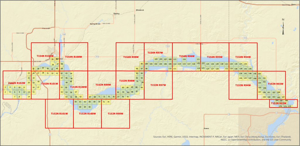
Users have the ability to locate the status for the various acreage adjustments through an interactive PDF or by utilizing the clickable map book:
User may enter the portal directly by clicking the map image below, then clicking on a specific Township/Range/Map Book Number. The Department of Trust Lands’ portal will take the user directly to the section for an overview of the current status; or
In order to access the PDF, please click the Acreage Adjustment Map Book link below. Once the PDF has downloaded the user can search through the various survey maps and click the Acreage Adjustment Status Link at the top of each map. Those links will take the user directly to the Department of Trust Lands’ portal where users can find the current status of the adjustments pertaining each map.
- Acreage Adjustment Map Book (PDF) - November Update
- Technical Report (PDF)
- GIS Database (ZIP) – Geodatabase running through ArcMap software
- GIS Shapefile (ZIP)
- GIS Shapefile T152 R93W Section 10 & 11 (ZIP) - November Update
- PLS Signed Plats (PDF) - November Update
- Acreage (Excel) - November Update